For more information and Full Evaluation Report, Click here
During
schematic design, the study team will continue to develop
these alternatives to a higher level of detail and incorporate,
as appropriate, comments and concerns from the project's public
and study work groups. The following are key concerns raised
during the Phase 2 alternative refinement and which the designers
will remain aware of during schematic design:
-
Include opportunities for urban design
- Minimize
business and right-of-way impacts
- Maximize/lengthen
weaving areas between ramps
- Allow
for improved access/circulation

During
the Phase 2 refinement of the alternatives, the study team
continued to develop the alternatives from Phase 1 to a higher
level of detail and incorporate, as appropriate, comments
and concerns from the public and study work groups. The following
are concerns raised during the first phase of alternative
development:
- Include
opportunities for urban design
- Include
access from Woodall Rodgers to DNT
- Freeway
to freeway access is improved but local access is more limited
- Provide
more direct access to/from the Industrial Boulevard area,
Colorado Boulevard, and Beckley Avenue - Cadiz should not
be made one-way
- Minimize
impacts to businesses and right-of-way impacts, especially
in the Mixmaster area - Utilize the recently completed northbound
IH 35E/HOV bridge
- Check
for planned development districts along the corridor which
could escalate right-of-way costs
- Maximize/lengthen
weaving areas between ramps
- Include
more quantitative information
The
study team refined the remaining alternatives between August
and December 2002. During this time, meetings continued with
the Project Coordination and Community work groups. Public
Meetings were held in January 2003 to gain additional public
input. After the Public Meetings, the preferred alternative
was selected for final revisions per agency/public input.
This preferred alternative will be further refined during
Phase 3 - Schematic Design.
During
Phase 2, the study team developed the conceptual designs from
Phase 1 that were selected for further evaluation. To allow
for public review and comment, the alternatives have been
placed on this website for information purposes only. PLEASE
NOTE, THESE PRELIMINARY PROJECT LAYOUTS ARE NOT INTENDED FOR
CONSTRUCTION, BIDDING OR PERMIT PURPOSES AND ARE SUBJECT TO
CHANGE WITHOUT NOTICE. Larger drawings were displayed at Public
Meetings held in January 2003. The following maps are in pdf
format:
| The
PDF items are in Adobe Acrobat® Portable Document Format
(PDF). Notice: The mentioning of brand names is
strictly for informational purposes and does not imply
endorsement or advertisement of a particular product by
the Texas Department of Transportation. Acrobat is a registered
trademark of Adobe System, Incorporated. The reader may
be downloaded from Adobe at: http://www.adobe.com/prodindex/acrobat/readstep.html
|
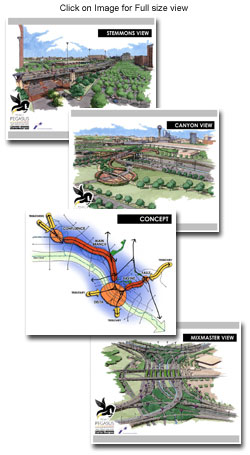
Phase 2: IH 30 Canyon from
IH 35E to IH 45 (as of November 2002)
Phase
2: IH 30/IH 35E Mixmaster Interchange
Phase
2: IH 35E Stemmons from Commerce to the Oak Lawn (as of November
2002)
Phase 2: IH 35E Stemmons
from Oak Lawn to Motor Street (as of February 2003)
Phase 2: IH 35E Stemmons
from Motor Street to Empire Central (as of February 2003)

The
Phase 1 Conceptual Alternative Development developed numerous
alternatives and then evaluated them to determine how well
the alternatives addressed the identified objectives of the
Project Pegasus. Alternatives were compared to each other
and the No-Build Alternative using an established set of evaluation
criteria for traffic conditions in the design year of 2026.
The application of criteria and measures was intended to pinpoint
the major differences between alternatives, help facilitate
the decision of which alternative(s) should be developed further
in Phase 2, and balance design standards, safety, transportation
needs, costs, and social, economic, and environmental concerns.
Based
on the evaluation measures and criteria established, the following
alternatives have been recommended for further development
and evaluation:
- No-Build
Alternative
- IH
30 Canyon
- IH
30/IH 35E Mixmaster
- Alternative
M-1
- Alternative
M-2
- IH
35E Lower Stemmons
- Alternative
S-1 between Commerce and Oak Lawn
- Alternative
S-2C between Oak Lawn and Empire Central
For
more information and the full evaluation report, click
here.
PLEASE NOTE,
THESE PRELIMINARY PROJECT LAYOUTS ARE NOT INTENDED FOR CONSTRUCTION,
BIDDING OR PERMIT PURPOSES AND ARE SUBJECT TO CHANGE WITHOUT
NOTICE.
During
Phase 1, the study team has developed numerous conceptual
alternatives. To allow for public review and comment, the
alternatives have been placed on this website for information
purposes only. Larger drawings were displayed at the May 2002
Public Meetings (see Events Calendar for meeting summaries).
The following maps are in pdf format:
Phase
1 : IH 30 Canyon Section: from
IH 35E to IH 45
Phase
1 : Mixmaster: IH 35E/IH 30 Interchange
- Alternative
M-1 (2.6mb) Updated May 28, 2002
- Alternative
M-2 (2.6mb) Updated May 28, 2002
- Alternative
M-3 - Note: This drawing has not been developed
to the same level as M-1 or M-2 because realigning IH 35E
east of the TXU substation would introduce a more severe
geometric design than the existing alignment.
- Alternative
M-4 - Note: This drawing has not been developed to the
same level as M-1 or M-2 because of potential environmental
issues regarding elevating IH 35E over the Houston Street
Viaduct near downtown. If these issues can be resolved,
the design of the frontage and collector-distributor roads
will be included and would be similar to those shown in
M-2.
Phase
1 : IH35E Lower Stemmons: IH 30 to Dallas North Tollway
Phase
1 : IH 35E from Oak Lawn to Wycliff (4.6mb)
Phase
1 : IH 35E from Wycliff to North of Dolton (4.5mb)
Phase
1 : IH 35E from North of Dolton to South of Commonwealth
(4.6mb)
Phase
1 : IH 35E/SH 183 Interchange (5.0mb) Updated
May 28, 2002

Preliminary
recommended improvements from the Trinity Parkway Corridor
MTIS for IH 30, IH 35E, and the Mixmaster interchange include
the following major elements:
- Building
additional main lanes along the south side of the IH 30
Canyon to carry eastbound traffic, allowing the existing
eastbound IH 30 main lanes to be reconfigured for two-way
High Occupancy Vehicle(HOV) use through the area.
- Adding
collector-distributor roads along both sides of the IH 30
Canyon, beginning in the area of IH 45, and terminating
into Griffin Street East and West in the area of Ervay Street.
These particular frontage roads would be controlled-access
and specifically necessary for traffic management and capacity
purposes.
- Reconfiguring
the IH 30/IH 35E Mixmaster to allow through traffic on IH
30 and IH 35E to stay in the same lanes through the interchange,
rather than being forced to change lanes as in the current
configuration. Adding north-south lanes through the Mixmaster,
so that IH 35E traffic flows on a total of three (3) dedicated
main lanes in each direction.
- Adding
direct-connect ramps in the Mixmaster connecting IH 35E
(South R.L. Thornton Freeway) to the IH 30 (Tom Landry Highway)
for the northbound to westbound and eastbound to southbound
traffic movements.
- Constructing
collector-distributor roads on both sides of IH 35E (Lower
Stemmons) from the Reunion Arena area northward to Oak Lawn
Avenue. These particular frontage roads would be controlled-access
and specifically necessary for traffic management and capacity
purposes.
- Constructing
continuous collector-distributor roads alongside IH 35E
in the segment from Spur 366(Woodall Rodgers Freeway) to
the connection with the Dallas North Tollway, with allowance
for separating traffic streams to and from Spur 366 (the
Woodall Rodgers Freeway) and the Dallas North Tollway.
- Construction
of collector-distributor roads over the Trinity River along
both IH 30 and IH 35E.
- Constructing
an HOV system serving the major radial highways feeding
into the Dallas Central Business District (CBD).

Based
on the results of the Trinity Parkway Corridor MTIS, TxDOT
is beginning the second phase of project development for the
proposed reconstruction and widening of IH 30 and IH 35E in
Dallas County. This phase involves developing the Preliminary
Engineering (PE) and Environmental Assessment (EA) in accordance
with state and federal guidelines. Alternative development
and evaluation, public and agency involvement, schematic design,
urban design, and right-of-way and utility mapping are included.
The environmental documentation will be in the form of an
EA. The schedule for this effort is 36-months. This combined
planning effort will conclude with:
-
Identification of a Locally Preferred Alternative (LPA),
- Typical
cross-sections,
- Design
schematic,
- Interstate
access justification, and
- Final
environmental clearance through a Finding of No Significant
Impact (FONSI).
Planning
Schedule

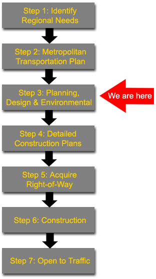 The
general process for building large transportation projects
involves many steps and can take 10 to 15 years before roadway
improvements are open to traffic. The flowchart on the left
shows the major steps.
The
general process for building large transportation projects
involves many steps and can take 10 to 15 years before roadway
improvements are open to traffic. The flowchart on the left
shows the major steps.
Regional
transportation needs are identified through a long-range planning
process involving local, regional, state and federal transportation
officials (Step 1).
The
process is based on current needs, future growth and available
transportation funding and the Metropolitan Transportation
Plan (MTP) for the next 20 years (Step 2). If warranted, Major
Investment studies are conducted during this process.
After
a project is included in the MTP, corridor-level planning
studies can begin. This step includes the development and
evaluation of alternatives, public and agency involvement,
environmental studies, preliminary design, and cost estimates
(Step 3). These more detailed planning studies will both determine
if a transportation project is feasible and will identify
potential effects on the community and environment.
Once
these studies are completed and approved by the Federal Highway
Administration (FHWA), more engineering is initiated to develop
detailed construction plans and right-of-way maps (Step 4).
Based
on the construction plans, the necessary right-of-way for
the project is acquired and any utilities such as power lines
and water lines can be relocated such that they do not interfere
with construction (Step 5).
When
the construction plans are completed, right-of-way acquired,
and funding secured - construction can begin (Step 6). As
with most large projects, it is anticipated the improvements
to IH 30 and IH 35E will be built in stages and could take
5 to 10 years to complete (Step 7).

Click
here to go to information about
Road Rage and how to avoid it.